ForAllPilotsFlying beyond limits
PPL · illustrated course

PPL navigation course: 12 illustrated chapters

The PPL navigation course follows the syllabus in 12 chapters: 91 key points explained in a few paragraphs, often with a diagram, what to remember and, for many, the classic exam trap. The first chapter, « The Earth, coordinates and distances », can be read in full on this page.

Contents

Each chapter explains, point by point, what the questions of the bank ask, with a « Remember » box and often the classic exam trap. The first chapter is free, below and in the app; the next ones are for PPL subscribers.

  1. Meridians, parallels, latitude, longitude, nautical mile, great circle and units.

    7 key points · 45 questions of the bank

  2. 2.Aeronautical charts

    Subscribers

    Projections, scale, measuring distances and tracks, reading the ICAO chart and airspace areas.

    9 key points · 99 questions of the bank

  3. 3.True, magnetic and compass north

    Subscribers

    Variation, deviation, heading and track: the True, Magnetic, Compass chain.

    7 key points · 126 questions of the bank

  4. 4.Wind: drift and the wind triangle

    Subscribers

    Wind, heading, track, drift, crosswind and effective wind, ground speed, calculating the heading to set.

    10 key points · 131 questions of the bank

  5. 5.Airspeeds, altimetry and levels

    Subscribers

    Vi, Vc, Vp, Vs and mental calculation; QNH, QFE, flight levels, semicircular rule.

    7 key points · 27 questions of the bank

  6. 6.Time, distance, fuel: mental arithmetic

    Subscribers

    Base factor, distance-speed-time relationships, fuel, equal-time point, descent.

    8 key points · 255 questions of the bank

  7. 7.UTC time, day and night

    Subscribers

    Coordinated universal time, legal time, shift of sunrise and sunset with longitude, aeronautical night.

    4 key points · 16 questions of the bank

  8. 8.Dead reckoning and pilotage

    Subscribers

    Preparing and conducting a VFR navigation: dead reckoning, landmarks, corrections, getting lost, weather, arrival.

    8 key points · 36 questions of the bank

  9. 9.VOR and direction finding

    Subscribers

    Radials, QDR and QDM, reading the VOR indicator, range, position fix from two VORs, VDF direction finding.

    12 key points · 67 questions of the bank

  10. 10.ADF, NDB and RMI

    Subscribers

    Automatic direction finder and NDB beacons: relative bearing, bearing, RMI, operating limitations.

    5 key points · 13 questions of the bank

  11. 11.GPS (GNSS)

    Subscribers

    Principle, information provided, BRG and TRK, estimates, accuracy, RAIM and good practice.

    6 key points · 24 questions of the bank

  12. 12.Radar, transponder and services

    Subscribers

    Primary and secondary radar, transponder and codes, radar vectoring, ATIS and radio services.

    8 key points · 27 questions of the bank
Chapter 1: The Earth, coordinates and distances

Meridians, parallels, latitude, longitude, nautical mile, great circle and units.

A rotating sphere

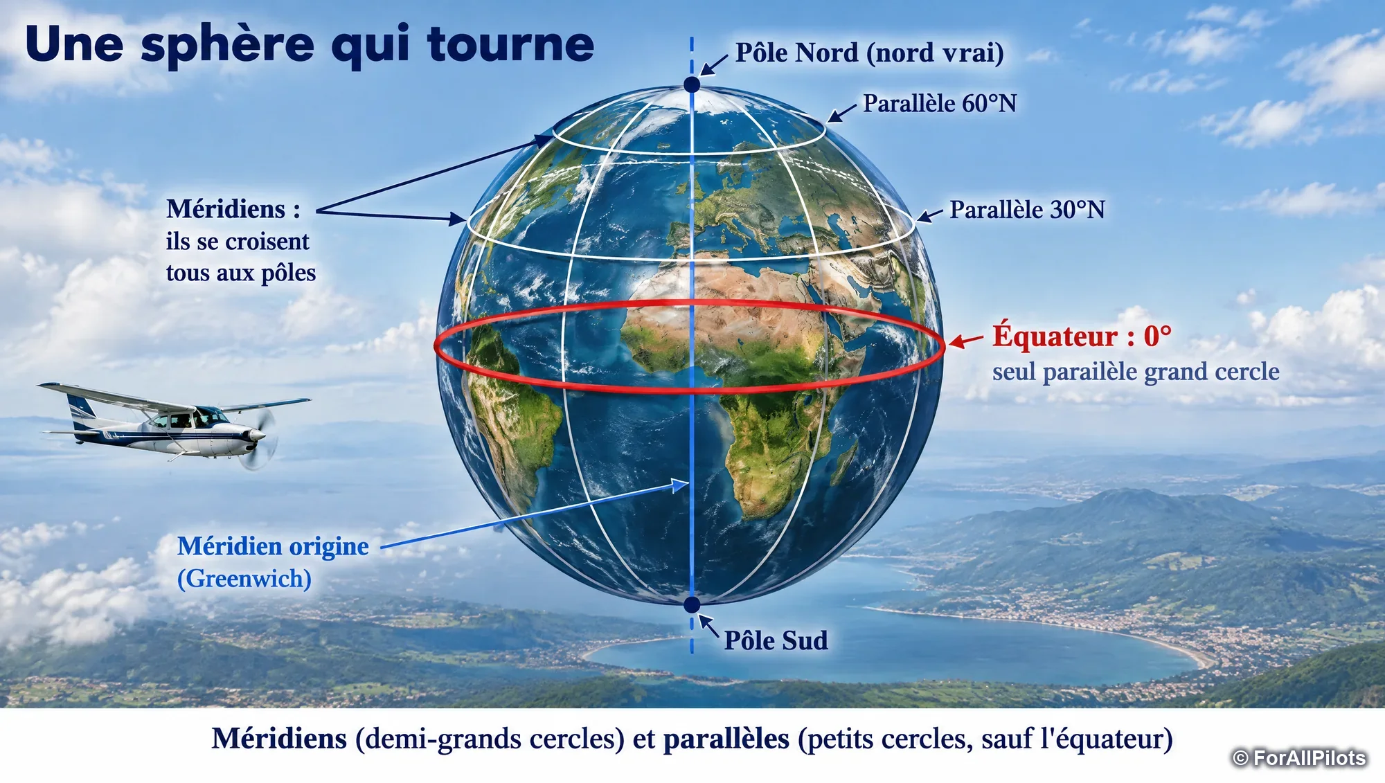
Meridians (half great circles) and parallels (small circles, except the equator)

Touchez l'image pour l'agrandir

Meridians (half great circles) and parallels (small circles, except the equator)

For navigation, the Earth is treated as a sphere that rotates about the polar axis. The geographic North Pole (or true north) is the point where this axis pierces the surface: its position is fixed.

  • A great circle has its centre at the centre of the Earth: it divides the Earth into two equal halves.
  • Meridians are half great circles that join the two poles: they all meet at the poles.
  • Parallels are circles parallel to the equator. The equator is the only parallel that is a great circle; the others are "small circles" whose circumference decreases as latitude increases, until it shrinks to a point at the pole.

Remember

Meridian = half great circle from one pole to the other. Equator = the only parallel that is a great circle. The poles are the intersection of all meridians.

Exam trap

The circumference of a parallel decreases as its latitude increases; it never depends on longitude. The 45°N parallel is therefore smaller than the equator and larger than the 60°N parallel.

Latitude and longitude

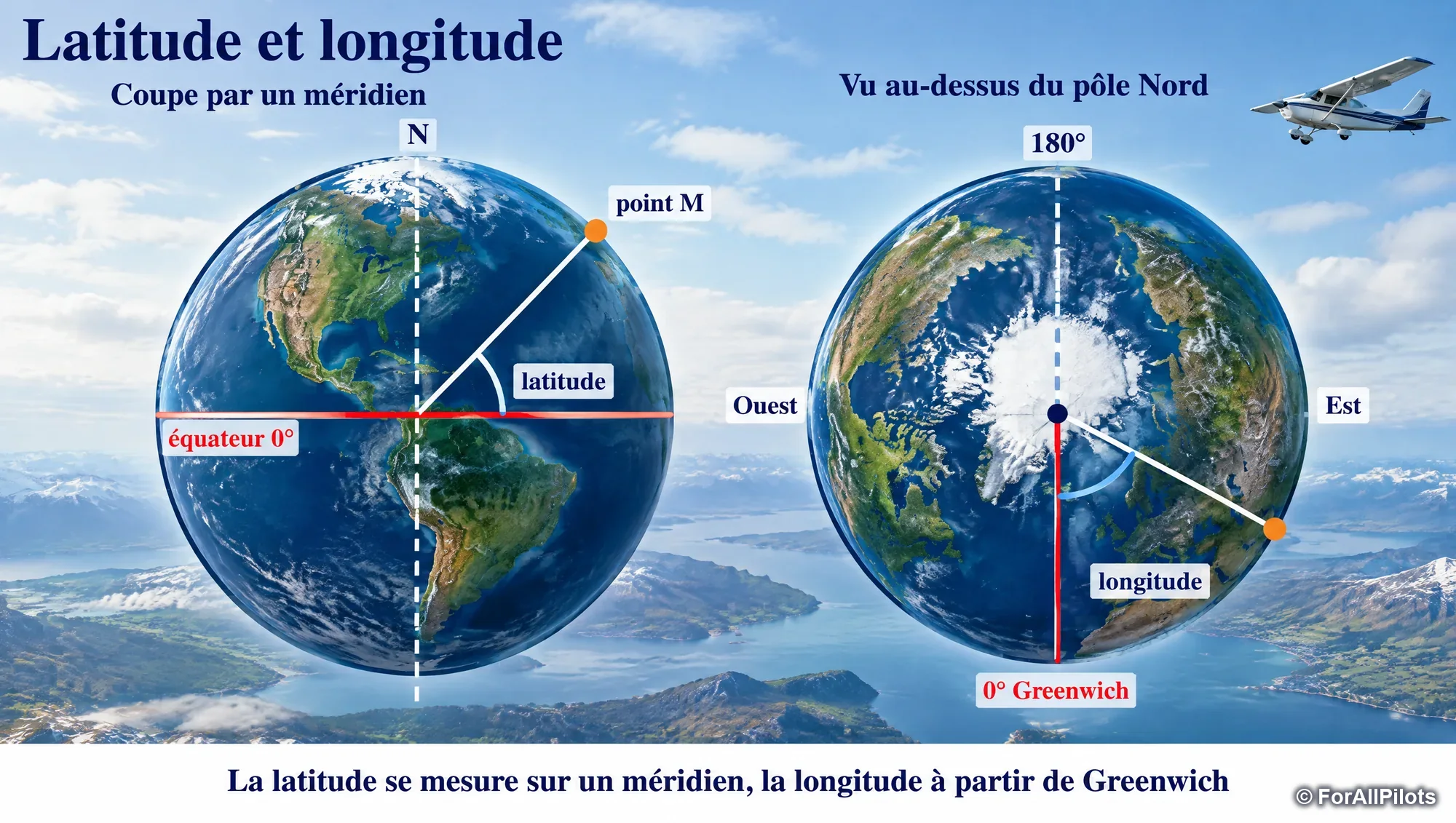
Latitude is measured along a meridian, longitude from Greenwich

Touchez l'image pour l'agrandir

Latitude is measured along a meridian, longitude from Greenwich

A point is located by two angles, measured from the equator and from the prime meridian (Greenwich).

  • Latitude is an angle measured along the meridian of the place, from the equator: from 0° to 90° North or South. The closer you get to a pole, the larger it becomes.
  • Longitude is the angle between the prime meridian and the meridian of the place: from 0° to 180° East or West.

Same latitude = same parallel; same longitude = same meridian. All points on the Greenwich meridian have a longitude of 0°.

Writing: latitude with 2 digits of degrees (45°00'N), longitude with 3 digits (002°56'E); minutes and seconds with 2 digits.

Remember

Latitude: 0 to 90° N/S from the equator. Longitude: 0 to 180° E/W from Greenwich. North Pole: 90°N (conventional longitude 000°).

Exam trap

"East latitude" or "North longitude" do not exist. A point east of Greenwich and south of the equator has East longitude and South latitude. The intersection of the equator and the antimeridian is written 00°N - 180°E (or W).

Locating yourself with coordinates

← Faites glisser le schéma →

Comparing latitudes and longitudes to locate one point relative to another

© ForAllPilots

Comparing two positions means comparing latitude and longitude separately.

  • A smaller latitude (Northern Hemisphere) = further south.
  • A smaller East longitude = further west (and the reverse for West longitude).

Example: an entry point at 44°09'N - 001°53'E relative to an aerodrome at 44°18'N - 002°04'E is further south and further west: it is to the south-west.

An aerodrome at 45°00'N is halfway between the equator (0°) and the pole (90°). The Greenwich meridian crosses France (near Le Havre and Tarbes): a flight from Nice (East longitude) to Brest (West longitude) crosses it, so the longitude changes from East to West.

Remember

45°N = halfway between equator and pole. In France, Greenwich passes near Le Havre and Tarbes.

The nautical mile: one minute of arc

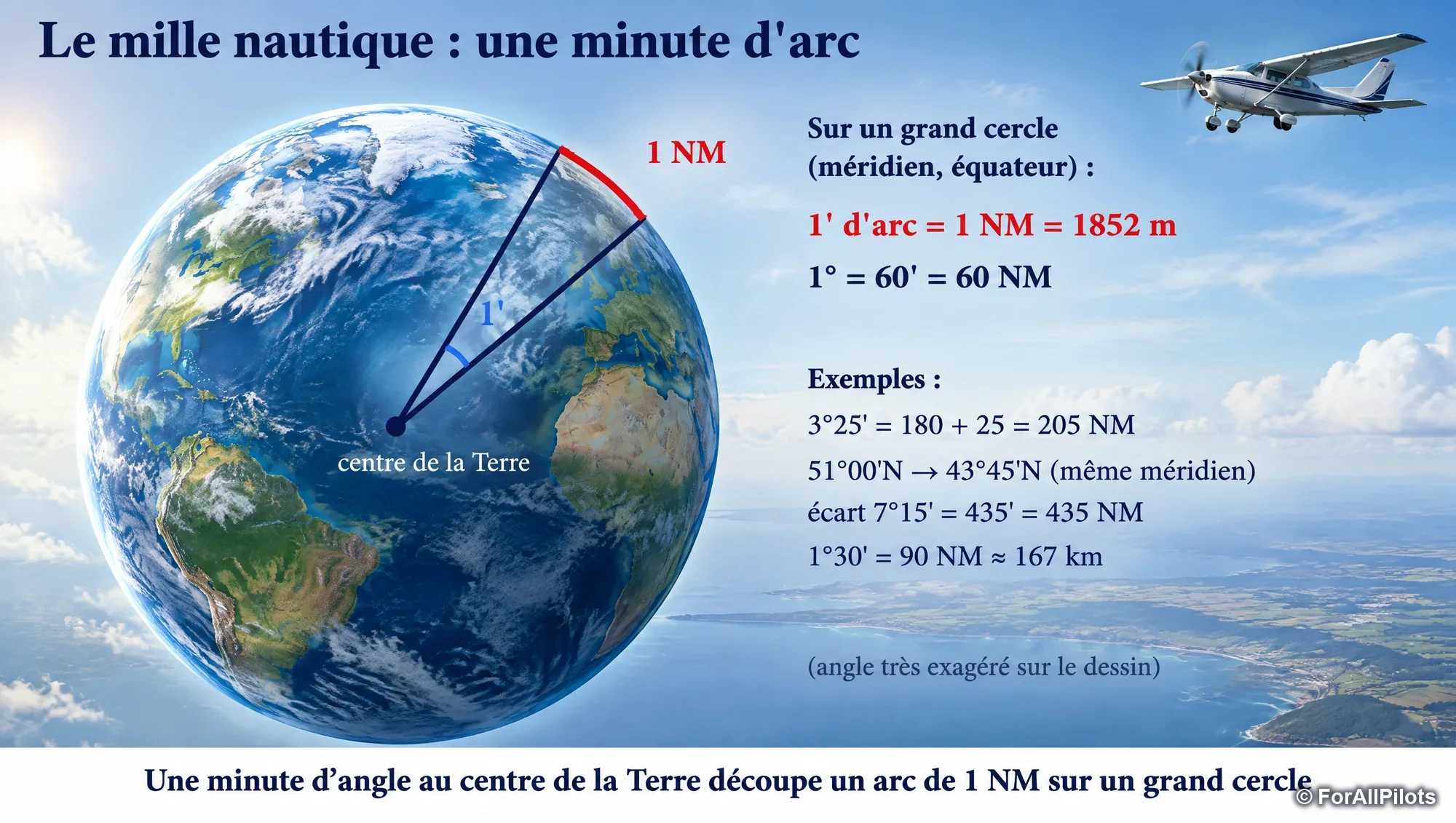
One minute of angle at the centre of the Earth cuts off an arc of 1 NM on a great circle

Touchez l'image pour l'agrandir

One minute of angle at the centre of the Earth cuts off an arc of 1 NM on a great circle

The nautical mile (NM) is defined from the Earth: it is the length of an arc of 1 minute (1/60 of a degree) measured along a great circle. It equals 1852 m.

A very practical consequence: along a meridian, a difference in latitude converts directly into distance.

  • 1' = 1 NM; 1° = 60 NM;
  • two points on the same meridian, 1° apart (30°N and 31°N), are 60 NM apart;
  • 10° of arc on any meridian always represents the same distance (600 NM), because all meridians are great circles.

Speed is measured in knots (kt): 1 kt = 1 NM per hour.

Remember

1 NM = 1852 m = 1' of arc of a great circle. 1° = 60 NM. Difference in latitude in minutes = distance in NM (along a meridian).

Exam trap

Check the unit requested: 1°30' along a meridian gives 90 NM, i.e. about 167 km (90 × 1.852).

Along a parallel, this is no longer true

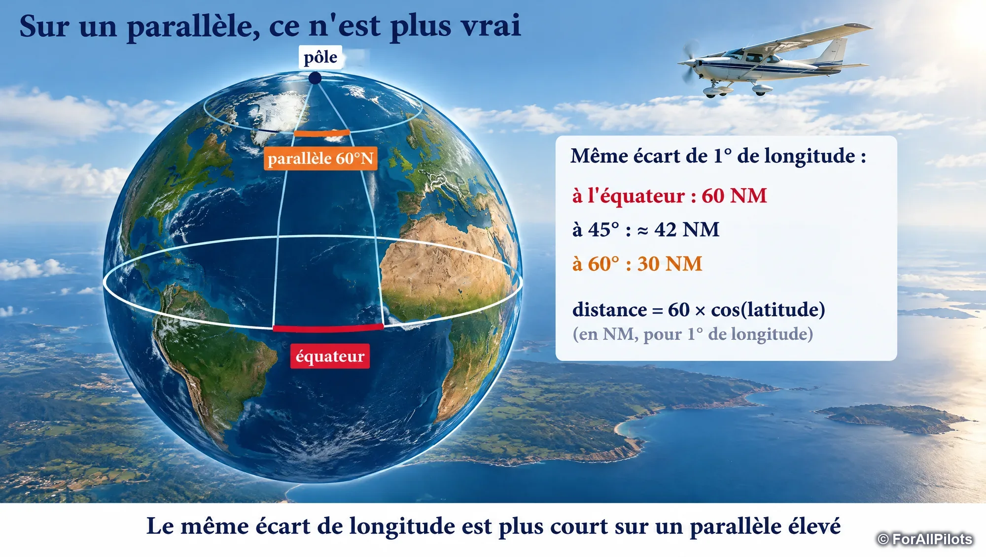
The same difference in longitude is shorter on a higher parallel

Touchez l'image pour l'agrandir

The same difference in longitude is shorter on a higher parallel

Parallels (except the equator) are small circles. One degree of longitude along them therefore represents less than 60 NM, and the less so the closer you get to the pole:

  • distance for 1° of longitude ≈ 60 × cos(latitude) NM;
  • at 45°: about 42 NM; at 60°: 30 NM; at the pole: 0.

This is why, on a chart, a distance is always measured by transferring it to a meridian (latitude scale), never to a parallel or to the horizontal edge of the chart.

Remember

On any parallel other than the equator: 1° of longitude < 60 NM.

Exam trap

"One minute of angle = 1 NM on meridians and on parallels" is false: it holds only for great circles (meridians, equator).

Great circle and rhumb line

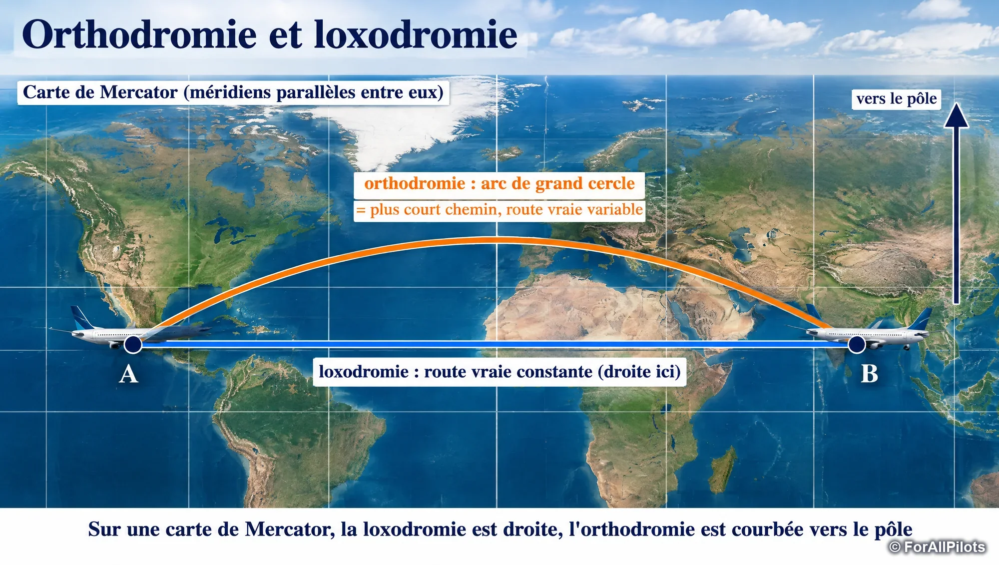
On a Mercator chart, the rhumb line is straight, the great circle is curved towards the pole

Touchez l'image pour l'agrandir

On a Mercator chart, the rhumb line is straight, the great circle is curved towards the pole

Between two points, there are two particular paths:

  • the great circle (orthodrome) follows the arc of a great circle: it is always the shortest path, but its true track varies along the route;
  • the rhumb line (loxodrome) crosses all meridians at the same angle: the true track is constant, but the route is longer.

A meridian is both a great circle and a rhumb line (track 000° or 180°), as is the equator. Any parallel is a rhumb line (track 090° or 270°) but not a great circle.

Flying the same heading for a very long time (no wind, magnetic variation assumed constant) amounts to following a rhumb line.

Remember

Great circle = shortest. Rhumb line = constant true track. Meridian = both at once.

Exam trap

The great circle is the shortest route "in all cases", not only along the equator. And the rhumb line is defined by a constant true track.

Navigation units

← Faites glisser le schéma →

Table of common conversions

© ForAllPilots

In aviation, the usual horizontal distances are expressed in nautical miles (NM), speeds in knots (kt), and heights and altitudes in feet (ft).

Conversions to know for the exam (calculator not allowed):

  • NM to km: × 1.852 (30 NM = 55.5 km); km to NM: ÷ 1.852 (37 km = 20 NM);
  • the statute mile (the unit of airspeed indicators in mph) equals 1609 m;
  • 1 m ≈ 3.28 ft; 1 ft ≈ 0.3 m;
  • 1 US gallon ≈ 3.785 l: 10 USG/h ≈ 38 l/h.

Remember

1 NM = 1.852 km; 1 SM = 1.609 km; 1 m = 3.28 ft; 1 USG = 3.785 l.

Exam trap

Do not confuse 1.852 (NM) and 1.609 (statute mile). "Mph" = statute miles per hour.

The course goes on with chapter 2, « Aeronautical charts ». It is read in the Course tab of the app with a PPL subscription, and each chapter ends with the questions of the bank about it. See pricing

How ForAllPilots trains you

  • Series of 20 or 30 questions

    New questions, mistakes to review or a mix of both, with the answer and its explanation straight away.

  • Flashcards

    Question on the front, explained answer on the back, filtered by subject, to learn without a timer.

  • Timed mock exam

    60 questions in 90 minutes, drawn from the whole PPL bank: a training format, not a copy of an official paper.

  • AI instructor, optional

    From €4.99 a month on top of the Private pilot or PRO offer: it quizzes you in writing and explains your mistakes. A beta tool, it does not replace an approved instructor.

PPL access comes with the Private pilot offer (BIA, PPL, microlight and helicopter): €10 a month, cancel anytime, or €69 once with the Exam Pass (18 months of access, nothing renews). Prices include all taxes.

The other PPL courses

All about the PPL exams: format, subjects and method