ForAllPilotsFlying beyond limits
ATPL · illustrated course

ATPL meteorology course: 14 illustrated chapters

The ATPL meteorology course follows the syllabus in 14 chapters: 157 key points explained in a few paragraphs, often with a diagram, what to remember and, for many, the classic exam trap. The first chapter, « The atmosphere, radiation and the standard atmosphere », can be read in full on this page.

Contents

Each chapter explains, point by point, what the questions of the bank ask, with a « Remember » box and often the classic exam trap. The first chapter is free, below and in the app; the next ones are for ATPL subscribers.

  1. Composition and layers of the atmosphere, tropopause, radiation balance, diurnal temperature cycle, ISA and ISA deviation calculations.

    11 key points · 102 questions of the bank

  2. 2.Pressure, isobaric surfaces and altimetry

    Subscribers

    Pressure and its decrease with altitude, standard pressure levels, contours, density, QFE/QNH/QFF/QNE settings, temperature errors and true altitude calculations.

    14 key points · 237 questions of the bank

  3. 3.Wind, from the surface to jet streams

    Subscribers

    Wind measurement, forces involved, geostrophic and gradient wind, friction layer, Buys-Ballot, drift and true altitude, thermal wind, jet streams.

    14 key points · 211 questions of the bank

  4. 4.Humidity, thermodynamics and stability

    Subscribers

    Vapour pressure and saturation, humidity variables, changes of state, adiabatic processes, cloud base, stability criteria, inversions and radiosondes.

    14 key points · 259 questions of the bank

  5. 5.Clouds and precipitation

    Subscribers

    Cloud formation and classification, identification in flight, flight conditions by genus, formation, types and regimes of precipitation, observation by satellite and radar.

    13 key points · 157 questions of the bank

  6. 6.Visibility, mist and fog

    Subscribers

    Definitions of visibility, mist, haze and lithometeors, conditions for the formation and dissipation of the various types of fog, visibility in precipitation.

    8 key points · 197 questions of the bank

  7. 7.Air masses, fronts and disturbances

    Subscribers

    Classification of air masses, European air masses, warm and cold fronts and occlusions, passage of a front, life of a polar front disturbance, warm sector and rear.

    13 key points · 201 questions of the bank

  8. 8.Pressure systems

    Subscribers

    Lows, highs, troughs, ridges, cols and pressure swamps; convergence, divergence and subsidence; dynamic and thermal systems, cold-air drops.

    7 key points · 108 questions of the bank

  9. 9.General circulation and climatology

    Subscribers

    General circulation model, centres of action, polar front and depression track, ITCZ, trade winds, monsoons, regional climates, winds on tropical routes, cyclones and easterly waves.

    13 key points · 192 questions of the bank

  10. 10.Terrain, breezes and local winds

    Subscribers

    Sea, land, slope and valley breezes, regional winds (mistral, bora, sirocco, foehn), flow over terrain, orographic waves and rotors, mountain flying.

    8 key points · 93 questions of the bank

  11. 11.Icing

    Subscribers

    Supercooled water, ICAO intensities, rime, clear and mixed ice, freezing rain and the frontal wedge, hoar frost, icing by cloud type, forecasting, effects and carburettor icing.

    10 key points · 159 questions of the bank

  12. 12.Thunderstorms and convective phenomena

    Subscribers

    Conditions of formation, types of thunderstorm, life cycle of a cell, hazards of the cumulonimbus, lightning, hail, tornadoes and use of radar.

    8 key points · 151 questions of the bank

  13. 13.Turbulence, CAT and wind shear

    Subscribers

    ICAO intensities, origins of turbulence, clear-air turbulence and jet streams, low-level wind shear, effects on the flight path, microbursts, detection and wake turbulence.

    10 key points · 116 questions of the bank

  14. 14.Weather messages and charts

    Subscribers

    METAR, SPECI, TREND and TAF, visibility and RVR, present weather, clouds and CAVOK, SIGMET and AIRMET, significant weather and wind charts, instruments and flight preparation.

    14 key points · 433 questions of the bank
Chapter 1: The atmosphere, radiation and the standard atmosphere

Composition and layers of the atmosphere, tropopause, radiation balance, diurnal temperature cycle, ISA and ISA deviation calculations.

What is air made of?

← Faites glisser le schéma →

Composition of dry air and the role of water vapour and aerosols

© ForAllPilots

Dry air is a mixture of nitrogen (78%), oxygen (21%), argon (0.93%) and traces (CO₂ ≈ 0.04%, neon, helium, ozone...). These proportions are constant up to about 80 km.

Moist air = dry air + water vapour. Vapour is an invisible gas; its share varies from 0 to 4% by volume (of the order of 1% at sea level in temperate latitudes). Yet it is the most important constituent in meteorology: its changes of state create clouds and precipitation, and transport heat (latent heat).

Aerosols (salt, dust, smoke) act as condensation and freezing nuclei.

Remember

Dry air: N₂ 78%, O₂ 21%, Ar ≈ 1%. Water vapour: invisible, ≈ 1% at the surface in temperate zones, almost all of it in the troposphere.

Exam trap

Fog, mist or a cloud is not vapour: it is droplets or crystals. The vapour itself cannot be seen.

Where is the mass of the atmosphere?

← Faites glisser le schéma →

Vertical distribution of the mass of the atmosphere

© ForAllPilots

Air is compressible: its density decreases with altitude, so the mass is concentrated at the bottom.

  • 50% of the mass is below ≈ 5.5 km (the pressure there is ≈ 500 hPa);
  • 90% below ≈ 16 km;
  • 99% below ≈ 30-32 km;
  • 99.999% below ≈ 100 km (the "practical" thickness of the atmosphere).

The troposphere contains about three quarters of the mass and nearly all the water vapour and aerosols: it is the "weather" layer. Transport aircraft fly in the troposphere and lower stratosphere, where exposure to ionising radiation increases with altitude and latitude.

Remember

50% below 5.5 km, 90% below 16 km, 99% below 32 km.

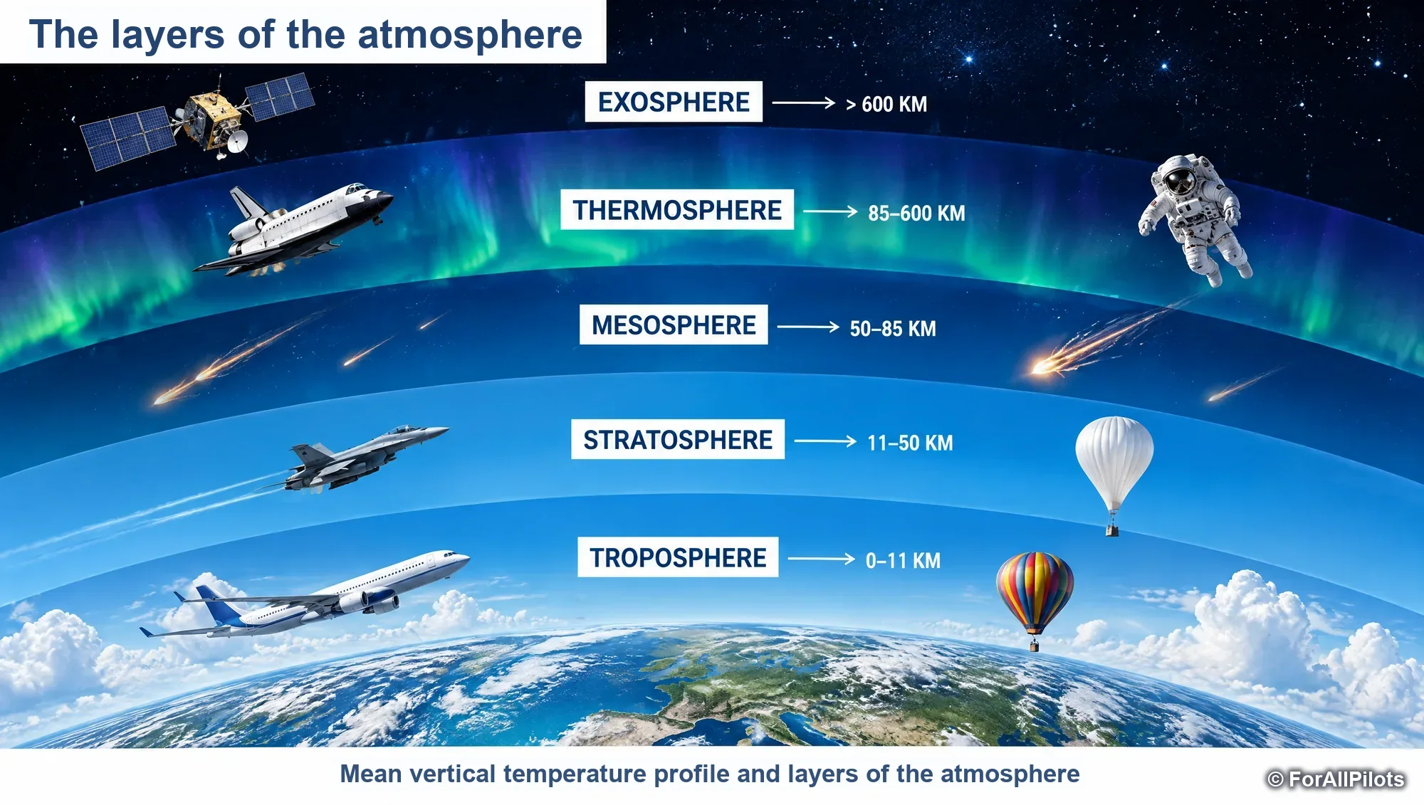
The layers of the atmosphere

Mean vertical temperature profile and layers of the atmosphere

Touchez l'image pour l'agrandir

Mean vertical temperature profile and layers of the atmosphere

The atmosphere is divided according to the vertical variation of temperature:

  • troposphere: temperature decreases with altitude (on average 6.5 °C/km); mean thickness ≈ 10-11 km;
  • tropopause: the boundary where the decrease stops;
  • stratosphere (≈ 11 to 50 km in temperate latitudes): temperature first constant, then increasing; ozone there absorbs solar ultraviolet radiation, hence the warming. Very stable air, few clouds;
  • stratopause at about 50 km, then the mesosphere.

Remember

Layers defined by temperature. Stratospheric ozone: absorbs UV and warms the stratosphere.

Exam trap

The layers are not defined by pressure or by composition. The stratopause separates the stratosphere from the mesosphere (not from the troposphere).

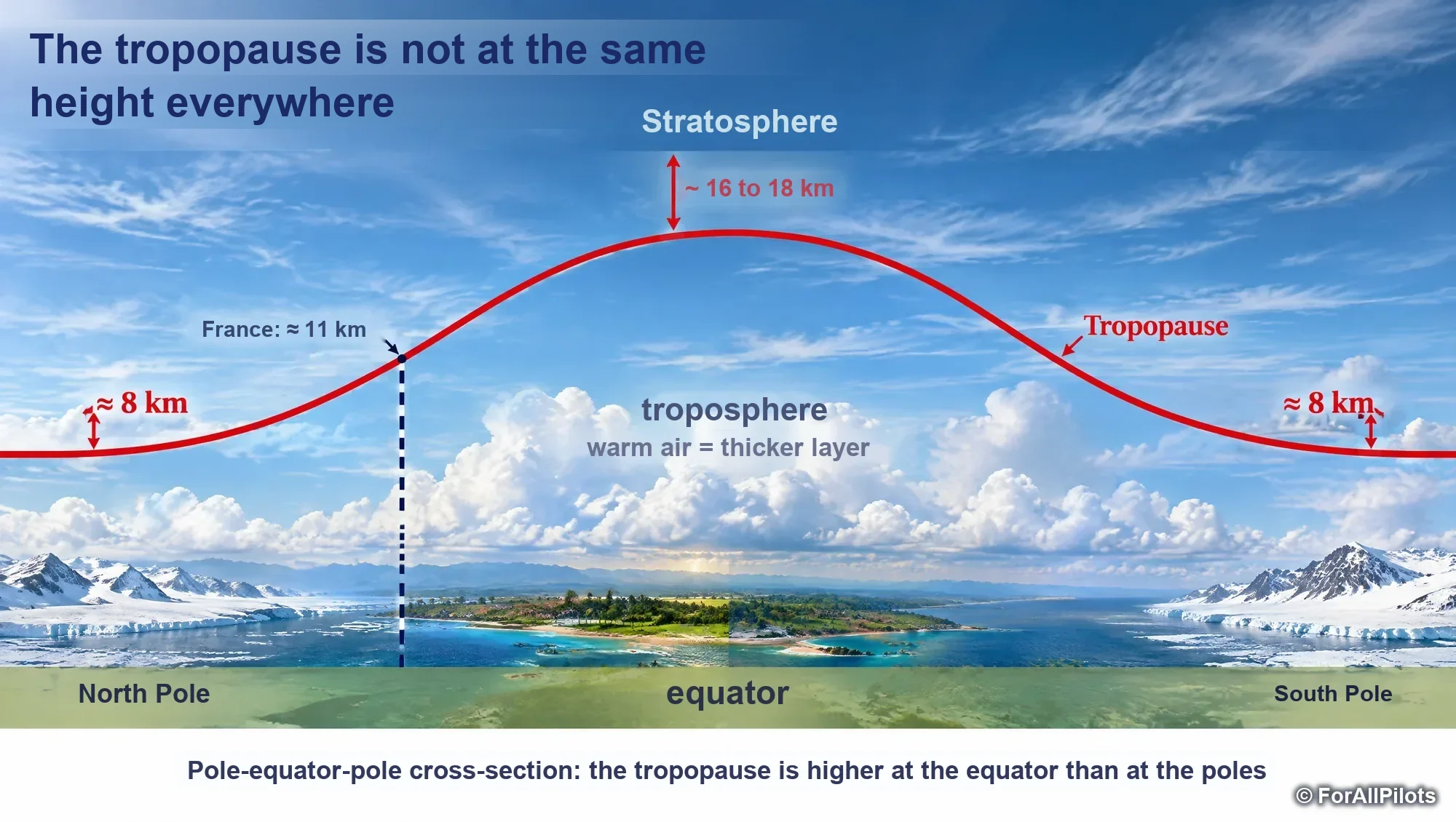
The tropopause according to latitude

Schematic meridional cross-section of the tropopause, from the pole to the equator

Touchez l'image pour l'agrandir

Schematic meridional cross-section of the tropopause, from the pole to the equator

WMO definition: the tropopause is the lowest level, above 5,000 m, at which the vertical lapse rate falls below 2 °C/km over a thickness of at least 2 km.

Its height depends on latitude and air mass:

  • equator: ≈ 16-17 km, ≈ −75 to −80 °C;
  • mid-latitudes: ≈ 11 km, ≈ −55 °C;
  • poles: ≈ 7-8 km, ≈ −45 °C.

Rule: the higher the tropopause, the colder it is (the layer in which temperature falls is thicker). Warm air has a high, cold tropopause; cold air has a low, "warm" tropopause. It shows breaks near fronts and jet streams.

Remember

Equator 17 km/−75 °C, 45° 11 km/−55 °C, pole 7 km/−45 °C. High = cold.

Exam trap

The coldest tropopause on the globe is the equatorial one, not the polar one. In the northern hemisphere, its height decreases from south to north.

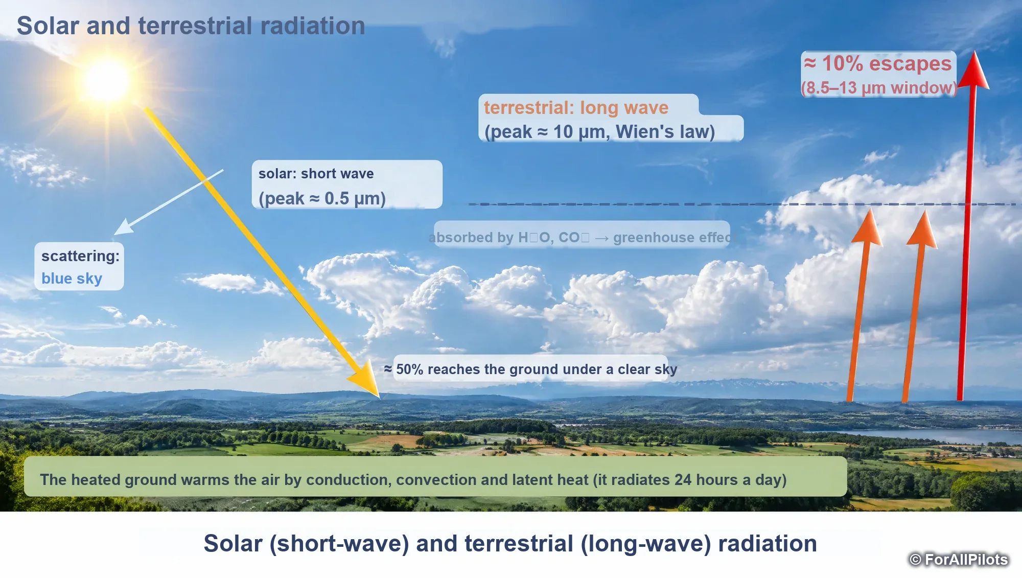
Solar radiation and terrestrial radiation

Solar radiation (short waves) and terrestrial radiation (long waves)

Touchez l'image pour l'agrandir

Solar radiation (short waves) and terrestrial radiation (long waves)

Every body radiates according to its temperature (black-body law); Wien's law places the maximum emission at a wavelength inversely proportional to the temperature.

  • the Sun (≈ 6,000 K) emits in short waves (≈ 0.5 µm): in clear skies, ≈ 50% reaches the ground directly, and part is scattered (blue is scattered more: blue sky, red Sun at the horizon);
  • the Earth (≈ 288 K) emits day and night in long waves (≈ 10 µm); water vapour and CO₂ absorb most of it: only ≈ 10% escapes, through the 8.5-13 µm "window" used by infrared satellites.

The air is therefore heated by the ground, not directly by the Sun.

Remember

Solar ≈ 0.5 µm, ≈ 50% at the ground in clear skies. Terrestrial ≈ 10 µm, ≈ 10% escapes. The ground radiates 24 h a day.

Exam trap

Solar radiation first heats the surface of the Earth, which then heats the troposphere.

Albedo and radiation balance

← Faites glisser le schéma →

Annual radiation balance as a function of latitude

© ForAllPilots

Albedo is the ratio of energy reflected (by scattering) to incident energy. Fresh snow and ice 0.8-0.95 (the highest), clouds 0.4-0.9, grassland 0.1-0.3, forest 0.05-0.2; average of land surfaces ≈ 0.3.

Over a year, the radiation balance is in equilibrium only on a global scale: it is in surplus in the intertropical zone and in deficit at the poles. Atmospheric and oceanic circulation carries the surplus towards the poles.

At the ground, the surplus energy returns to the atmosphere ≈ 25% by convection and 75% by evaporation; this latent heat is given back to the air during condensation. Convection and condensation are therefore the main processes that warm the atmosphere.

Remember

Maximum albedo: snow, ice. Balance: + between the tropics, − at the poles. Surplus from the ground: 25% convection, 75% evaporation.

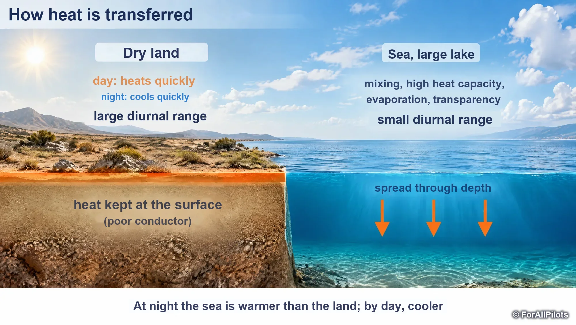
How heat is transferred

Why the sea varies little in temperature and the ground a lot

Touchez l'image pour l'agrandir

Why the sea varies little in temperature and the ground a lot
  • Radiation: electromagnetic waves, needing no material medium.
  • Conduction: contact between molecules or between the air and the ground. Air is a poor conductor: a very cold ground cools only a thin layer (hence surface inversions).
  • Convection: air heated from below rises (vertical motion).
  • Advection: horizontal transport of air and its properties.
  • Turbulence and latent heat (evaporation/condensation).

Dry continental ground keeps heat at the surface: it heats and cools quickly. A body of water distributes heat in depth: its surface varies little. Over the sea, the day/night range is small and the night temperature is higher.

Exam trap

The exam wording says that "water is a good conductor": in reality it is mainly mixing, high heat capacity and evaporation that stabilise its surface. Remember the conclusion: small diurnal range over water, large over deserts.

The diurnal temperature cycle

← Faites glisser le schéma →

Diurnal variation of temperature in clear and overcast skies

© ForAllPilots

In clear skies and light wind over a continent:

  • minimum about half an hour after sunrise (the ground is still losing more than it receives);
  • maximum at about 14:00 solar time (about 2 h after the Sun crosses the meridian).

The range is greatest in clear skies, light wind, dry ground: desert areas. A thick, low cloud layer greatly reduces it (by day it blocks the sun, at night it sends terrestrial radiation back); thin, high clouds reduce it little. Example: on a winter evening at +3 °C, the night will be around −5 °C in clear skies but stays around 0 °C, or just below +3 °C, under a stratus overcast.

Relative humidity varies inversely: maximum around daybreak, minimum around 14:00.

Remember

T min ≈ ½ h after sunrise, T max ≈ 14:00. RH max at sunrise. Low, thick clouds = small range.

Exam trap

The minimum temperature does not occur at midnight or at the exact moment of sunrise, but just after.

The ICAO standard atmosphere (ISA)

← Faites glisser le schéma →

Values of the ICAO standard atmosphere

© ForAllPilots

The International Standard Atmosphere (ISA) is a model of dry air built from averages at 45°N. It serves as the reference for altimeters, airspeed indicators and performance.

At mean sea level: 1013.25 hPa (29.92 inHg), +15 °C, 1.225 kg/m³.

Temperature decreases by 6.5 °C/km (1.98 °C/1000 ft, rounded to 2 °C/1000 ft) up to the tropopause at 11 km (36,090 ft), where it is −56.5 °C. It remains constant up to 20 km (65,617 ft), then increases by 1 °C/km up to 32 km. The lowest ISA temperature is therefore −56.5 °C.

Remember

ISA: 1013.25 hPa, +15 °C, 1.225 kg/m³, −2 °C/1000 ft up to 36,090 ft, then −56.5 °C up to 65,617 ft, then +1 °C/km.

Calculating an ISA temperature and a deviation

← Faites glisser le schéma →

Typical ISA temperature and deviation calculations

© ForAllPilots

Below the tropopause: T(ISA) ≈ 15 − 2 × Z, with Z in thousands of feet (FL/10).

The ISA deviation (ISA ± ΔT) is the difference between the actual temperature and the standard temperature at the same level. It is generally assumed to be constant over the vertical: to go from one level to another, the standard lapse rate (2 °C per 1000 ft) is applied starting from the measurement.

Typical examples: FL 300 in ISA+15 → −45 + 15 = −30 °C; −35 °C at FL 200 → ISA−10; −12 °C at FL 140 → −6 °C at FL 110; −40 °C at FL 300 → −36 °C at FL 280.

Remember

ISA T = 15 − 2·(FL/10). Descending 1000 ft: +2 °C; climbing 1000 ft: −2 °C.

Exam trap

Above 36,000 ft, the standard temperature no longer changes: −56 °C measured at FL 390 also gives −56 °C at FL 370 when applying the model.

The scales of phenomena

← Faites glisser le schéma →

Space-time scales in meteorology

© ForAllPilots

Meteorology classifies phenomena according to their size and lifetime:

  • local scale: a few km, from a few tens of minutes to a few hours (slope and valley breezes);
  • mesoscale (aerological scale): from 1 to a few tens of km, of the order of an hour (thunderstorm, tornado, convection cells);
  • synoptic scale: hundreds to thousands of km, several days (depressions and anticyclones, fronts);
  • general circulation: from continent to hemisphere, months to a year (monsoons, alternation of dry and wet seasons).

Vertical motions at the synoptic scale are slow (a few cm/s) but involve entire air masses.

The course goes on with chapter 2, « Pressure, isobaric surfaces and altimetry ». It is read in the Course tab of the app with a ATPL subscription, and each chapter ends with the questions of the bank about it. See pricing

How ForAllPilots trains you

  • Series of 20 or 30 questions

    New questions, mistakes to review or a mix of both, with the answer and its explanation straight away.

  • Flashcards

    Question on the front, explained answer on the back, filtered by subject, to learn without a timer.

  • Timed mock exam

    100 questions in 150 minutes, drawn from the whole ATPL bank: a training format, not a copy of an official paper.

  • AI instructor, optional

    From €4.99 a month on top of the Private pilot or PRO offer: it quizzes you in writing and explains your mistakes. A beta tool, it does not replace an approved instructor.

ATPL access comes with the PRO offer (which also includes Private pilot): €19.99 a month, cancel anytime, or €129 once with the Exam Pass (18 months of access, nothing renews). Prices include all taxes.

The other ATPL courses

All about the ATPL exams: format, subjects and method